The Romans, or should I say Romano-British, were
in trouble in Kent in the late third century because the natives were
getting restless, both the ones across the sea and those across the
Scottish border. The biggest problem was the tribes from
Germany that we call Saxons, Franks, Angles and Jutes; the Germanic tribes of
Europe were increasingly raiding our, or the perhaps I should say, the Romano-British coast and
seaways perhaps preparing for a full scale invasion as had happened on
the Continent; something had to be done about this
threat of invasion and minor piracy and, of course, this
contempt for Rome.
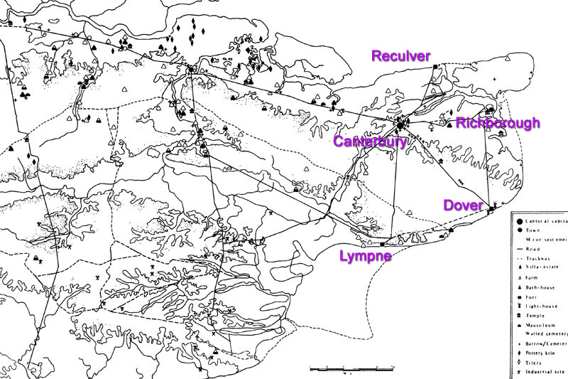
All around the coast from
Norfolk to Hampshire the Romans built a series of large forts, at
harbours where trade was focussed. Inland towns too were fortified
with walls. The forts are built on a
massive scale, I have included the four Kent ones in these pages as
you will have seen, they may have been used as bases for the Classis
Britannica, the British fleet.
The nine still in existence are often mentioned
but there were more even in France and Belgium. These UK forts are: Branodum (Brancaster),
Gariannonum (Burgh Castle), Othona (Bradwell) Regulbium (Reculver),
Rutupiae (Richborough), Dubris (Dover) Lemanis (Lympne), Anderitum (Pevensey)
& Adurni (Portchester).
The earliest of the Saxon
Shore forts may
have been Reculver in its latest form dating from ca. 230AD
(remember a small version was in place just after Claudius' 43AD arrival)
while the others may have been built later, according to coin finds,
in the period ca. 260 to 285 AD.
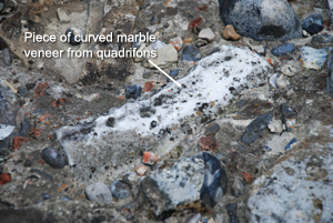
 The Dover Saxon Shore fort was the
third fort to be built on its site but Richborough was perhaps the finest.
In its previous incarnation with its Quadrifons it was gateway to
Britannia, although this was removed on the building of the Saxon
Shore
fort. Some parts of the original marble veneer (left) can still be
seen at the fort embedded in pieces of the wall. The fort
was still occupied right up to the end of Roman rule in the 5th
century and may have been the last place to be evacuuated.
The Dover Saxon Shore fort was the
third fort to be built on its site but Richborough was perhaps the finest.
In its previous incarnation with its Quadrifons it was gateway to
Britannia, although this was removed on the building of the Saxon
Shore
fort. Some parts of the original marble veneer (left) can still be
seen at the fort embedded in pieces of the wall. The fort
was still occupied right up to the end of Roman rule in the 5th
century and may have been the last place to be evacuuated.
There is only one written source for the
existence of Saxon Shore forts and that is the
Notitia
Dignitatum a document dating
to the turn of the 4/5th century, it lists these nine military installations
and their garrisons as Castrorum Litus Saxonicum, hence the name we
give them. Apart from being stationed with soldiers or marines the forts must also have
contained catapults and ballistae (hence the bastions seen on
forts) and been capable sheltering the
local population (one assumes?) and withstanding a
prolonged, determined siege from overseas.
Not all the forts are the same
shape or size, Lympne is pentagonal and Reculver square, but they
all have massive stone walls (not all with bonding courses) with
projecting bastions or towers, they seem to have had earth rampart
inside the walls and a protective ditch, or ditches in the case of Richborough, surrounding them. Not so much is known
of the insulae within the forts but we can imagine there were
granaries, storerooms, baths, administrative blocks, temples, altars and so
on. One thing is sure - they were well built - it is a testament to
the Roman
construction method that they are still standing, in most cases
metres high, (even after being robbed for stone blocks) after two millennia.
Continental sea pirates were a serious problem for
the Romans with any town or village anywhere near the coast or navigable
channel vulnerable to attack. But consider the investment required to quarry
all the stone from afar, create the lime mortar from chalk and charcoal,
move it, build the fort walls, dig the ditches, garrison the forts
continually, feed the men, cut firewood, and a host of other
considerations. Communications needed to be kept up to date as well with
semaphore, signal, or beacon sites manned and every inlet policed somehow.
But all this work can't have been just for the sake of a
few pirates in longboats from Denmark. It is easy to be
blinkered by the Saxon Shore forts around the southeast but one must remember at this
time inland cities across Britannia were being fortified too. On
the Continent there had recently been large scale raids by
Franks into Belgium and France.
Archaeological evidence
apparently provides information that places near coasts were burned
down, large towns inland like Canterbury had their walls rebuilt or
fortified. Even seeing the destruction of the extensive Roman Painted House
or mansio in
Dover to make way for the new Classis Britannica fort, cut
straight through it, makes me think this threat was an
important, serious issue and that drastic actions were undertaken quickly. This was the beginning of the end but did the Romans know it, I
wonder?