A BRIEF
HISTORY OF FURZEFIELD
RECENT
TIMES...
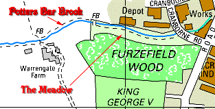
The County
Council bought 40 acres of land in 1935 called
Furzefield; it lay between Mutton Lane and Cranborne Road
sewage farm. Eighteen acres of this land was to be
developed into a sports facility to which the King George
V Memorial Foundation promised a grant. World War II
delayed the project but the playing field and a pavilion
(converted from the British Legion Memorial Hall)
was opened in 1957.
150
YEARS AGO
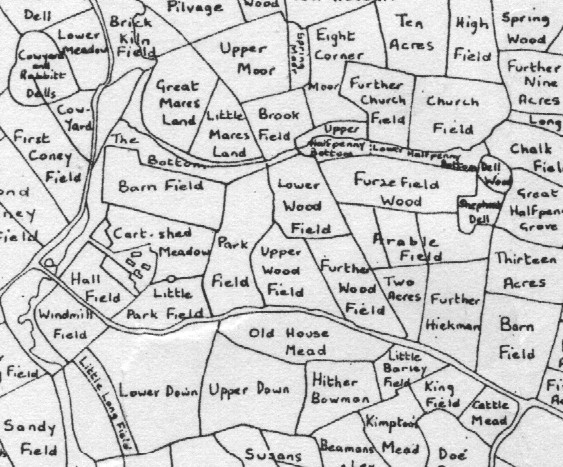
The earliest
reference I found to the name Furzefield Wood is 1842 Tithe Map. A mid-19th
century map of the area shows Furzefield Wood. This mid-19th
century Map of Field Names has Furzefield Wood marked in
more or less the same shape as today. The Furzefield
meadow where the Potters Bar Brook runs is there too
and split in two fields - Upper and Lower Halfpenny
Bottom. At the eastern end of the wood there are
also two small areas - Dell Wood and Shepherd's
Dell. The King George Playing field is marked as
Arable field (existing oaks on the field in 1998 are
indicators of these old field boundaries). There are two
other fields called Two Acres and Further
Hickman marked.
400
YEARS AGO...
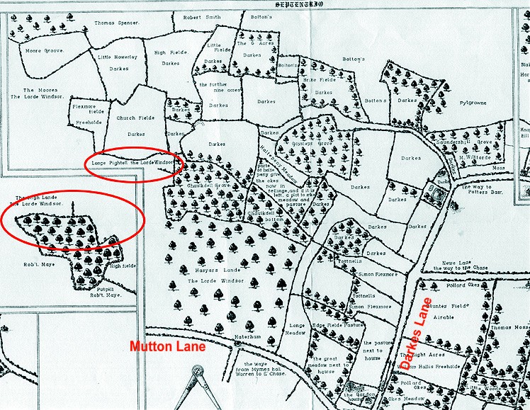
An earlier map
still, the 1594 map of
Ralph Treswell (Wyllyots Manor) doesn't show the
Furzefield wood but the meadow is shown: look for Longe
Pightell* the Lorde Windsor. I overlaid the 1594 map
and present day map on computer, lining up Mutton
Lane, Darkes Lane and Billy Lows (New Lane on the 1594 map) and the
correlation is very good. The area of the Potters Bar
Golf Club also matches the field boundaries very well in
places. Furzefield Wood then in those times was part of a
much larger piece of woodland called Hasyars Lande. [*Pightell (Old Eng.) = pightle = pingle
= enclosed field.]
900
YEARS AGO...
Before this time
the history of the Manor of South Mimms, which I assume
always contains Furzefield, is rather complicated because
South Mimms actually moved its position and its ownership
changed many times. By 1086 the
Domesday Book contains a reference to South Mimms (Mimes)
as a berewic and part of the Manor of Edmonton.
The site of the first South Mimms is likely to have been where
the twelfth century South Mimms Castle stood.
|